Simulation
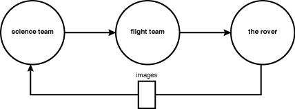
In order to test the success of our design, we simulated a streamlined version of the lunar reconnaissance rover field test that we observed earlier in the summer. The goal of the design was to help scientists convey their planning goals, so the simulation was centered around scientists’ ability to build a plan and express their intent, and the flight team’s ability to interpret and execute that intent.
The Science Team
The science team consisted of 1-2 geologists from NASA or local universities in the area. They were given an overview of the simulation's goals, and the ability of the rover and its instruments. Then, using our tool, they created a plan to evaluate the traversability and potential scientific value of sites marked on the map.
In order to determine how well our planning tool was able to capture the scientists' intent, the science team was not allowed to communicate directly with the flight team or rover team, and had to communicate any rationale or special instructions through the planning tool.
The Flight Team
The flight team consisted of 1-2 people from the HCI group at NASA, or the lunar reconaissance field test. After receiving a completed plan from the science team, Flight was given the task of interpreting the plan and transcribing it into step by step instructions for the rover to carry out. This included the GPS coordinates, the compass heading the rover should be facing, and observations to carry out at each waypoint. Flight was also allowed to adjust the plan to avoid any unexpected hazards that the science team was unaware of, but was asked to explain any adjustments they made in the tool's “notes” field. Flight was not allowed to ask the science team questions, and was asked to use his or her best judgement in order to interpret the plan.
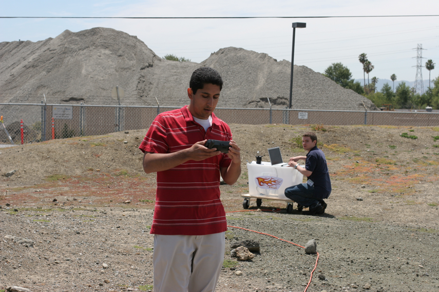
The Rover
The rover for this simulation was a human-powered cart, equipped with two digital cameras to act as the panoramic camera and microscopic imager, a GPS, and a compass so the rover could move to the correct location. The rover team was also given a walkie-talkie to receive instructions from flight, and report their progress.
The Procedure
The science team was instructed to explore the map in order to assess interesting geological areas within the region, and also to evaluate the traversability of the terrain for a future crewed mission. The flight team was given operating constraints that would force them to alter the science team’s plan in some way before relaying it to the rover team. No communication between the science and flight teams was allowed outside of the planning tool. The ORTs allowed us to assess whether our tool was successfully capturing the science team’s planning goals within the planning tool itself. If the flight team changed the plan but was still able to capture the same data products requested by the science team, this was deemed successful. We used screen-capture and voice recording to document the participants' interactions with the tool, and followed-up each ORT with a qualitative assessment and debrief with all participants.