Tool Bar
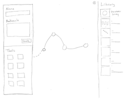
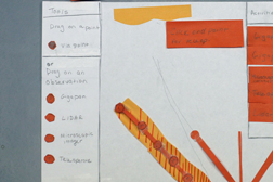
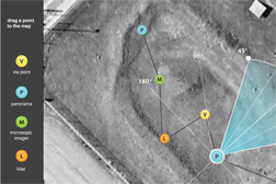
Keeping with the minimal, walk‐up‐and‐use design, the tool bar contains a clear list of the toolset available to the science team. The tool bar includes a via point, a gigapan panorama, a microscopic image, and a lidar scan. Selecting each tool adds it to the activities list, where users can input the reason of using the instrument and see the settings available for the instrument.
Supporting Data
On the Mars missions and the field test, scientists did not interact directly with the planning tool because the tools were very complex and required extensive training. In order to allow scientists to communicate exactly what they want through a planning tool, common tools and settings need to be easily accessible so many different people can learn the planning tool quickly. The minimalist tool list design streamlines the method to add new points and supports the walk-up-and-use design.
Testing
The first version of the tool bar required users to drag out a via point first, then add observations to it if they chose. In addition to our final list of four tools, the tool list included options for a “hypothetical” waypoint, a teleoperation waypoint, a microscopic image sequence, and a 360-degree lidar.
After our first round of user tests on the paper prototype, we revised the design so that users could begin by dragging out any observation they chose, not necessarily a via point, reducing the number of steps needed to get observations into the plan. In addition, the “hypothetical” waypoint was removed because we decided that hypothetical plans were outside the scope of our focus. The teleoperation waypoint was also removed because we determined that the choice of whether to teleoperate or not should should be left up to the flight team rather than the science team.
The 360-degree lidar was removed from the tool list after several rounds of user testing with the digital prototype. Users consistently did not see the option when asked to place a 360-degree lidar scan, instead using the regular lidar tool and setting it by hand to 360-degrees. Similarly, users rarely noticed the MI sequence option, instead laying out points by hand. In addition, the MI sequence felt out of place on the tool bar since it laid out multiple points while the other tools laid out a single point. The tool's concept however, received very positive feed back, so while it was removed from the tool bar, we redesigned it to be an option within the single MI. Users would place a single MI, then have the option of setting it to a multipoint series which would unlock the options for number of points and interval. Unfortunately due to time constraints this redesign did not make it into the final Landing Day evaluation, but since this tool received very positive feed back during user tests we felt it really addressed the goal of visualizing planning, so we made an effort to include the concept in the final implementation.


