Notes Field
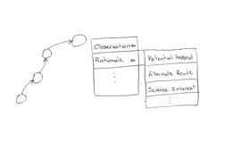
While generating waypoints in a plan, scientists are prompted to enter the rationale behind the request. This gives the science team a place to capture some of the discussion that took place when considering possible waypoints. The flight team can use this information to interpret exactly what the science team is trying to accomplish at each waypoint. In addition, the science team can use this information during data analysis to help direct them to the specific reason an image was requested. Intent information can be provided for an entire plan, as well as specific waypoints and observations.
Supporting Data
The main goal of our design is to give scientists the ability to clearly communicate the intent of their plan to the flight team. This goal was derived not only from research during the spring semester, but also supported by our observations of the robotic reconnaissance field test. On the MER and Phoenix missions, there were many instances where instrument engineers would have to clarify with the scientists exactly what sort of data they were trying to get and why. Similarly on the field test, the flight team asked the science team questions to make sure they were interpreting their plan correctly. The intent field will not only facilitate this understanding, but also allow the science team to look back and remember their own reasons and discussions behind past plans.
Testing
Like the settings panel, the notes field initially started as a pop-up that would appear when the user clicked on a point and selected an option to “add intent”. The note field was soon moved to the task list both to save screen real-estate and to make it more easily accessible with the ever present “add note” button.
Users responded positively to the note icon and the ability to preview the note to by rolling over it with the mouse. However, there some cases where users did not seem to notice the “add” button below the text box that would save their note, resulting in many lost notes. This was later iterated on by having the intent save as soon as text was entered in the field, however this resulted in saving notes the user was not necessarily ready to save.
Testing our tool during the ORTs inspired some important changes in preparation for the final simulation. In the ORTs both the flight team and science team added notes to the points: science would describe the rationale behind the point, and flight would describe any changes made. Initially, flight would append their comments to the same comment box as flight, but we observed that sometimes it was difficult to tell where a new note was added, and occasionally prior notes would be accidentally deleted or altered.
We addressed these issues by designing the notes field more around a “conversation”. When a note is added, it would be appended to the conversation with the appropriate “Flight” or “Science” label and can no longer be edited.


